The peak of Stožina is located on the territory of the Durmitor National Park above the Pošćenska dolina. This is far from the highest point of Durmitor, however, due to its picturesqueness, it has become one of the symbols of the national park and one of the most frequently photographed peaks. It is called the gateway to South Durmitor.
Savin kuk is one of the most famous peaks of the Durmitor National Park in Montenegro. Together with the Šljeme ridge (Montenegrin: Šljeme, in the photo - to the left of the central point of the picture), Savin kuk (the top is slightly to the right) makes up the eastern outskirts of the central part of Durmitor.
The mountain reaches a height of 2313 meters above sea level and offers excellent panoramas from it.

However, to a greater extent, the popularity of Savin kuk is associated not with the views, but with the ski resort of the same name, located on its slopes.
It follows from this that visiting the summit can be very easy: you just need to get by car to the ski lifts, with their help, get to the top in a few minutes, and in the finale, walk a little along the gentle slope.
But hiking, of course, can cover the entire journey on foot. The same option will have to be used by visitors who come in the off-season, when the cable cars do not work.

In general, the trail to Savin kuk starts at the Black Lake, but at a certain moment it leads just to the ski lifts.
The length of the path from the lake to the ski resort is 4 km. The road takes about 1.5 hours if you go slowly. The trail is laid through a coniferous forest, belongs to the category of family routes, is marked, in the network of hiking paths it is designated under the number 111. It starts on the left side of the main approach to the lake (behind the restaurant).
If you want to save time and effort, you can, as I said earlier, drive to the ski resort by car. This time we did not have the opportunity to go the whole route, so we did so.
From Žabljak there is a good asphalt road. If you move in the direction from the city of Šavnik, then the path is older and worse, but also with an asphalt surface. You can leave your car in the free marked parking near the ski lifts and start your ascent from there. In this case, the starting point is at an altitude of 1456 meters above sea level.

You need to keep to the dirt road paved by SUVs.
The marking does not start immediately, but after about 10-15 minutes you will notice the characteristic red and white circles.
However, their presence will not change anything at this stage - you still need to go along the dirt road almost to its very end.

Although you have to walk along the road, it is quite interesting. At least if you are walking on it for the first time.

As you ascend, you can admire the outlines of the approaching peak and the Šljeme ridge.

And look back at the valley with small houses. It looks very good, especially in the morning light. 
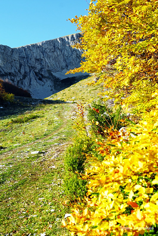
If you go in the autumn period, then along the way you will also get to enjoy the bright foliage of beeches a little.

They are real ambassadors of autumn in the mountains of Montenegro.
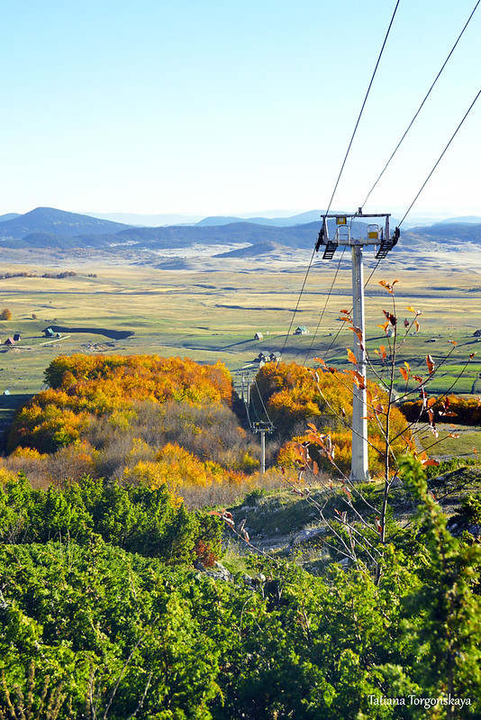
On this part of the way you will be continuously accompanied by ski lifts.

There are 6 of them in total (2 chair, 3 ground, 1 children's ground). They work, of course, during the ski season.
But in the warm season, chair lifts are also launched for tourists. Usually they ride visitors from 10:00 to 16:00. The opening and closing dates of the summer season vary from year to year depending on the weather, the number of tourists and other factors, but on average, this period begins in June and ends by the second half of September.

For the last couple of years, the fare (on 2 lifts) in the summer is 8 euros for adults and 5 euros for persons under 14 years old.
In winter, the price is the same, however, taking into account that the second, upper lift, in the cold season, is often closed due to strong winds.
If you go from the parking lot of the ski resort, then the whole route can be divided into three parts:
1. To the finish of the first chair lift "Savin kuk I".
2. To the finish of the chair lift "Savin kuk II".
3. From there directly to the top of the mountain.
The first part of the path is a continuous uphill climb.
There are no dangerous and difficult sections on it. The dirt road follows the cable car "Savin kuk I".

Building between the tracks "Dernek" and "Panalj". Here, by the way, one of the marks entered the frame. It can be seen that the marking is bright and noticeable.
In general, the designation of routes in Durmitor is not always good, but specifically here everything is fine with the marks - they are located quite often and it is not difficult to find them, there are no controversial places where you can go astray.

And here you can see the final point of the first chair lift - there is the same as in the previous picture, a small house with a gable roof.

Looking down from the top platform of the "Savin kuk I" lift. The height in this place is 1907 meters above sea level.

From here, those who climb up with the help of the cable car will have a short walk to the right and transfer to the Savin kuk II lift.
And tourists climbing on foot need to go in the opposite direction.

Almost immediately after the first lift, the road ends and the real hiking route begins.
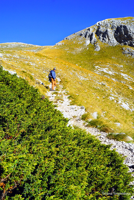
In combination, the most difficult path awaits tourists here - climbing the scree.

The climb here is sharp, and such screes are areas with increased risk, since there is very mobile material underfoot.

Although if you follow the safety rules:
to go in dry weather, in good sports (or better - designed specifically for hiking) shoes, take hiking sticks, be careful and not leave the path laid along the most stable part of the mountain - then everything goes well and turns out to be not so difficult and scary as it might seem at first.

However, it is precisely because of the scree that the route falls into the category of medium difficulty. And, most likely, people with no experience in mountain walks or families with small children will find it very uncomfortable to walk here. It is better for these categories of tourists to use an alternative - lifts, or choose simpler trails.

The road to Savin kuk, by the way, was laid at the beginning of the 20th century. It was made especially for the Montenegrin ruler Nikola I Petrović-Njegoš. It is also one of the first marked trails in Montenegro - it was marked in 1935.

Part of the trail has changed after the construction of the ski center, but its first stage - from the lake to the ski lifts, and the entire upper part (from the scree) remained the same.
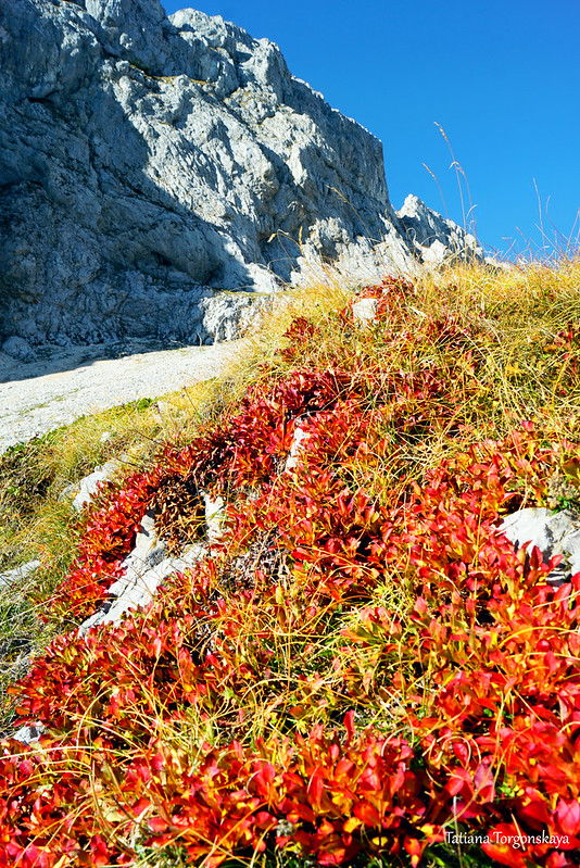
The scree itself, in fact, is located between the top of Savin Kuk, located on the right, and the Šljeme ridge, on the left (pictured). From below, it does not look particularly impressive, but as it rises, it becomes more and more picturesque.

A peculiar attraction of this part of Durmitor are wild goats.

They can often be seen on the slopes of the ridge, especially out of season when Durmitor's attendance drops.

Goats, of course, are shy, and when a person approaches, they quickly leave.

But even from a distance to watch their movements is very interesting.

After the scree, the route is transformed into a normal and safe mountain trail.
On this section of the route, as well as on the very top, snow can remain until June, so summer and the first half of autumn are considered the best time for climbing.

Landscape between the Šljeme Ridge and Savin Kuk.

Soon the path leads to an open area overgrown with low grass.

To the right of the path there will be a small hill above the cliff.
The marking goes straight to the final landing of the second chairlift, but you can make a small detour and come to the edge of this part of the mountain.

From here you have a good view.

Here is a general panorama towards Žabljak.

A couple of close-ups of the area at the foot.


Jagged rocks belonging to the Šljeme Ridge.

One of the pillars of the second chairlift.

After looking around, we return back to the trail and come to the finish area of the cable car.
It takes about 2 hours to get from the ski resort parking lot to this point - with a medium step with a couple of short pauses. If you go at a good pace without stopping, it is quite possible to overcome the distance in 1.5 hours.
The descent can take less time. Personally, we went down half an hour faster.

Here we will interrupt. The next post will be devoted to the final stage of the ascent to Savin Kuk and the panoramas from it.
Comments
Post a Comment